Parameters [Builder]
Please consider the following:
- Python does not recognize operating system environment variables, please use full paths in the parameters file (no
$HOMEetc). - These parameters determine how scenery objects are generated offline as described in chapter Scenery Generation.
- All decimals need to be with “.” — i.e. local specific decimal separators like “,” are not accepted.
- Unless specified otherwise then all length is in metres and areas are in square metres.
- You do not have to specify all parameters in your
params.pyfile. Actually it is better only to specify those parameters, which you want to actively control — the rest just gets the defaults.
View a List of Parameters
The final truth about parameters is stored in parameters.py — unfortunately the content in this chapter of the manual might be out of date (including default values).
It might be easiest to read parameters.py directly. Python code is easy to read also for non-programmers. Otherwise you can run the following to see a listing:
/usr/bin/python3 /home/vanosten/develop_vcs/osm2city/parameters.py -d
If you want to see a listing of the actual parameters used during scenery generation (i.e. a combination of the defaults with the overridden values in your params.py file, then you can run the following command:
/usr/bin/python3 --file /home/pingu/development/osm2city/parameters.py -f LSZS/params.py
Important Parameters
Minimal Set
See also Setting a Minimal Set of Parameters.
| Parameter | Type | Default | Description / Example |
|---|---|---|---|
| PREFIX | String | n/a | Name of the scenery project. Do not use spaces in the name. |
| PATH_TO_SCENERY | Path | n/a | Full path to the scenery folder without trailing slash. This is where we will probe elevation and check for overlap with static objects. Most likely you’ll want to use your TerraSync path here. |
| PATH_TO_SCENERY_OPT | List | None | Optional additional paths to scenery folders (e.g. for Project3000). Specified as a list of strings (e.g. [‘/foo/uno’, ‘/foo/due’]. Only used for overlap checking for buildings against static and shared objects. |
| PATH_TO_OUTPUT | Path | n/a | The generated scenery (.stg, .ac, .xml) will be written to this path. If empty
then the correct location in PATH_TO_SCENERY is used. Note that if you use
TerraSync for PATH_TO_SCENERY, you MUST choose a different path here.
Otherwise, TerraSync will overwrite the generated scenery. Unless you know
what you are doing, there is no reason not to specify a dedicated path here.
While not absolutely needed it is good practice to name the output folder
the same as PREFIX. |
| PATH_TO_OSM2CITY_DATA | Path | n/a | Full path to the folder with osm2city-data. See chapter Installation of osm2city (e.g. “/home/user/osm2city-data”). |
| FG_ELEV | String | n/a | Points to the full path of the fgelev executable. On Linux it could be
something like .../bin/fgfs_git/next/install/flightgear/bin/fgelev'.
On Windows you might have to put quotes around the path due to whitespace
e.g. '"D:/Program Files/FlightGear/bin/Win64/fgelev.exe"'. |
| PROBE_FOR_WATER | Boolean | False | Checks the scenery in PATH_TO_SCENERY whether points are in the water or
not. The FlightGear scenery’s water boundaries might be different from OSM.
E.g. removes buildings if at least one corner is in the water. And removes
or splits (parts of) roads/railways, if at least 1 point is in the water.
Only possible with FGElev version after 9th of November 2016 / FG 2016.4.1. |
Important Flags
| Parameter | Type | Default | Description / Example |
|---|---|---|---|
| FLAG_COLOUR_TEX | Boolean | False | Experimental code. If True then the texture and OSM tags can use colouring. For later versions of FlightGear (2019.x?). |
| FLAG_STG_BUILDING_LIST | Boolean | False | If True then some buildings use the Random Building code in FlightGear instead of a building mesh, which reduces scenery size and can help with rendering performance. |
| BUILDING_USE_SHARED_WORSHIP | Boolean | False | Use a shared model for worship buildings instead of OSM floor plan and heuristics. The shared models will try to respect the type of building (e.g. church vs. mosque) and will in size (not height) respect the convex hull of the building floor plan in OSM. If the building is composed of several parts as in OSM 3D buildings, then no shared models are used - as it is assumed that the 3D modeling is more realistic (e.g number and height of towers) than a generic model, although the facade texture is more dumb than a typical shared model texture. |
| NO_ELEV | Boolean | False | The only reason to set this to True would be for scenery builders to
check generated scenery objects a bit faster not caring about the vertical
position in the scenery. |
Buildings
Diverse Parameters
Parameters which influence the number of buildings from OSM taken to output.
| Parameter | Type | Default | Description / Example |
|---|---|---|---|
| BUILDING_MIN_HEIGHT | Number | 0.0 | Minimum height from bottom to top without roof height of a building to be included in output (does not include roof). Different from OSM tag “min_height”, which states that the bottom of the building hovers min_height over the ground. If set to 0.0, then not taken into consideration (default). |
| BUILDING_MIN_AREA | Number | 50.0 | Minimum area for a building to be included in output (not used for buildings with parent). |
| BUILDING_PART_MIN_AREA | Number | 10.0 | Minimum area for building:parts. |
| BUILDING_REDUCE_THRESHOLD | Number | 200.0 | Threshold area of a building below which a rate of buildings gets reduced from output. |
| BUILDING_REDUCE_RATE | Number | 0.5 | Rate (between 0 and 1) of buildings below a threshold which get reduced randomly in output. |
| BUILDING_REDUCE_CHECK_TOUCH | Boolean | False | Before removing a building due to area, check whether it is touching another building and therefore should be kept. |
| BUILDING_NEVER_REDUCE_LEVELS | Integer | 6 | Buildings that tall will never be removed in removing. |
| BUILDING_TEXTURE_GROUP_RADIUS_M | Integer | 0 | For BUILDING_LIST buildings, distance within which buildings will tend to have the same texture (e.g. in the UK, Netherlands). Heuristics are only used if value > 0. A typical value would be around 2000. |
In order to reduce the total number of nodes of the buildings mesh and thereby reducing both disk space volume and rendering demands as well as to simplify the rendering of roofs, the geometry of buildings is simplified as follows:
- Only if not part of a building parent
- Only if no inner circles
- Only if a multiple of 4 nodes gets reduced and always 4 neighbouring points are removed at the same time (e.g. something that looks like a balcony from above, but can also point inwards into the building)
- If points get removed, which are also part of a neighbour building, then the simplification is not accepted.
- The tolerance of the below parameters is respected.
| Parameter | Type | Default | Description / Example |
|---|---|---|---|
| BUILDING_SIMPLIFY_TOLERANCE_LINE | Number | 1.0 | The point on the base line may at most be this value away from the straight line between the node before the balcony and the node after the balcony. This in order to prevent that e.g. a stair-case feature is removed. |
| BUILDING_SIMPLIFY_TOLERANCE_AWAY | Number | 2.5 | The 2 points sticking out (or in) may not be more than this value away from the straight line between the node before the balcony and the node after the balcony. This in order to prevent clearly visible “balconies” to be removed. |
Level of Details of Buildings
The more buildings you have in LOD detailed, the less resources for rendering are used. However you might find it “irritating” the more buildings suddenly appear. Experiment with the settings in FlightGear, see also Adjusting Visibility of Scenery Objects.
| Parameter | Type | Default | Description / Example |
|---|---|---|---|
| LOD_ALWAYS_DETAIL_BELOW_AREA | Integer | 150 | Below this area, buildings will always be LOD detailed |
| LOD_ALWAYS_ROUGH_ABOVE_AREA | Integer | 500 | Above this area, buildings will always be LOD rough |
| LOD_ALWAYS_ROUGH_ABOVE_LEVELS | Integer | 6 | Above this number of levels, buildings will always be LOD rough |
| LOD_ALWAYS_DETAIL_BELOW_LEVELS | Integer | 3 | Below this number of levels, buildings will always be LOD detailed |
| LOD_PERCENTAGE_DETAIL | Decimal | 0.5 | Of the remaining buildings, this percentage will be LOD detailed, the rest will be LOD rough. |
Building Levels and Height
In OSM the height of a building can be described using the following keys:
building:heightroof:heightheight(the total of building_height and roof_height, but most often used alone)building:levelsroof:levels(not used in osm2city)levels
Most often none of these features are tagged and then the number of levels are determined based on the settlement type and the corresponding BUILDING_NUMBER_LEVELS_* parameter. The height is always calculated as the product of the number of levels times parameter BUILDING_LEVEL_HEIGHT_*. If only the height is given, then the levels are calculated by simple rounding — and this level value is then used for calculating the height. The reason for this is that some uniformity in building heights/values is normally observed in the real world — and because the generic textures used have a defined height per level.
An exception to this is made for building parts in a relationship (Simple 3D buildings), as the heights in this case might be necessary to be correct (e.g. a dome on a church).
There is some randomness about the number of levels within the same settlement type, which is determined by using a dictionary of level=ratio pairs, like:
BUILDING_NUMBER_LEVELS_CENTRE = {4: 0.2, 5: 0.7, 6: 0.1}
meaning that there is a ratio 0f 0.2 for 4 levels, a ratio of 0.7 for 5 levels and a ratio of 0.1 for 6 levels. I.e. the keys are integers for the number of levels and the values are the ratio, where the sum of ratios must be 1.
| Parameter | Type | Default | Description / Example |
|---|---|---|---|
| BUILDING_NUMBER_LEVELS_* | Dict | . | A dictionary of level/ratio pairs per settlement type, which is used when a
building does not contain information about the number of levels.
If the building class is not residential or residential_small and the
settlement type is not centre or block, then specific parameters
are used for apartments, industrial/warehouse and others. |
Visibility Underground Buildings
There seem to be challenges with consistency etc. in OSM in terms of deciding, whether something is under the ground and therefore osm2city should not render it.
According to findings in the FG Forum and OSM there are different tags used, some of them better suited than others according to OSM documentation:
location=undergroundorlocation=indoorseems to be a correct way (key:location)indoorhas also some usage (key:indoor)tunnelis according to taginfo (taginfo tunnel combinations) used max 1000 times together with buildingslevelwith negative values. NB: not to be confused withlevelsandbuilding:levels(see chapter Building Levels and Height)layeris not to be used to determine visibility (key:layer)
| Parameter | Type | Default | Description / Example |
|---|---|---|---|
| BUILDING_UNDERGROUND_LOCATION | Boolean | True | Do not show buildings or building:parts if key location has value
underground or indoor. |
| BUILDING_UNDERGROUND_INDOOR | Boolean | True | Do not show buildings or building:parts if key indoor is present and its
value is not no. |
| BUILDING_UNDERGROUND_TUNNEL | Boolean | True | Do not show buildings or building:parts if key tunnel is present and its
value is not no. |
| BUILDING_UNDERGROUND_LEVEL_NEGATIVE | Boolean | True | Do not show buildings or building:parts if key level has a negative value
and neither key levels or building:levels have a non-negative value. |
European Style Inner Cities (Experimental)
Given the available textures in osm2city-data and the in general limited tagging of buildings in OSM as of 201x, European cities look wrong, because there are too many modern facades used and too many flat roofs.
The following parameters try to “fix” this by adding OSM-tags roof:colour=red and roof:shape=gabled to all those buildings, which do not have parents or pseudo-parents (i.e. nor relationships or parts in OSM), but which share node references with other buildings. So typically what is happening in blocks in inner cities in Europe.
| Parameter | Type | Default | Description / Example |
|---|---|---|---|
| BUILDING_FORCE_EUROPEAN_INNER_CITY_STYLE | Boolean | False | If True then some OSM tags are enforced to better simulate European style buildings - especially in inner cities. |
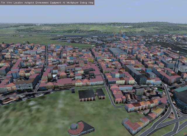
Example of using the flag set to True in a part of Prague:
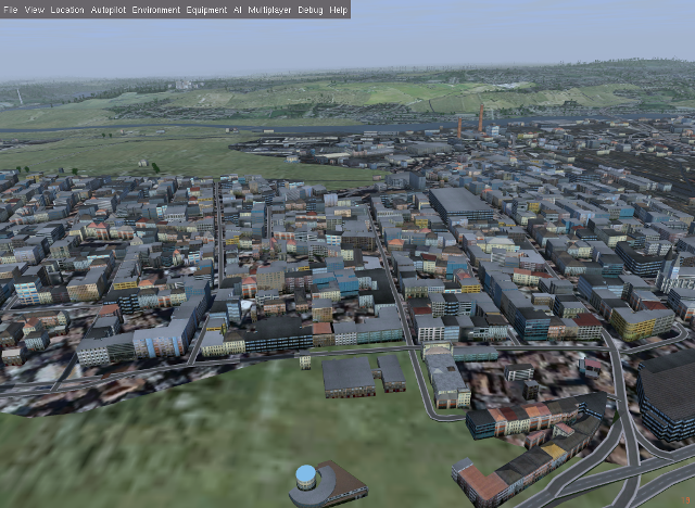
vs. setting it to False (default):
Roofs on Buildings
Below you will find quite a lot of parameters deciding what type of roofs should be generated on buildings. To understand the basic concepts, you should understand OSM Simple 3D buildings. With complex roof below all those roof types, which are not flat/horizontal are meant.
The following parameters decide whether a complex roof should be used on top of a building at all.
| Parameter | Type | Default | Description / Example |
|---|---|---|---|
| BUILDING_COMPLEX_ROOFS | Bool | True | Set this to false if only flat roofs should be used. Good for performance, but not so nice for the eye. If this is set to False, all other parameters do not matter. |
| BUILDING_COMPLEX_ROOFS_MIN_LEVELS | Integer | 1 | Don’t put complex roof on buildings smaller than the specified value unless
there is an explicit roof:shape flag in OSM. |
| BUILDING_COMPLEX_ROOFS_MAX_LEVELS | Integer | 5 | Don’t put complex roofs on buildings taller than the specified value unless
there is an explicit roof:shape flag in OSM. |
| BUILDING_COMPLEX_ROOFS_MAX_AREA | Integer | 1600 | Don’t put complex roofs on buildings larger than this. |
| BUILDING_COMPLEX_ROOFS_MIN_RATIO_AREA | Integer | 600 | If a building is larger than this but smaller than ..._MAX_AREA, then
it is compared whether the building tends to be small and long, because often
on more square buildings, which at the same time are large, the roof tends
to be flat. |
| BUILDING_SKEL_MAX_NODES | Integer | 10 | The maximum number of nodes for which a complex roof is generated. The higher the number, the longer the execution time but the more houses actually get realistic roofs. |
| BUILDING_ROOF_SHAPE_RATIO | Dict | . | If the roof:shape tag is missing in OSM (which it most often is), then
this parameter can help to make region specific decisions on what roof types
are to be applied randomly with a given ratio.
The sum of the ratios must give 1.0 and the values must be one of the values
defined for RoofShapes in roof.py. |
| BUILDING_ROOF_SIMPLIFY_TOLERANCE | Number | 0.5 | All points in the simplified roof will be within the tolerance distance of the original geometry. |
Finally the following parameters let you play around with how complex roofs are done.
| Parameter | Type | Default | Description / Example |
|---|---|---|---|
| BUILDING_SKEL_ROOFS_MIN_ANGLE | Integer | 10 | The minimum angle of the roof |
| BUILDING_SKEL_ROOFS_MAX_ANGLE | Integer | 50 | The max angle of the roof. Some randomness is applied between MIN and MAX. |
| BUILDING_SKILLION_ROOF_MAX_HEIGHT | Decimal | No matter the MIN and MAX angles: a skillion will have at most this height difference. | |
| BUILDING_SKEL_ROOF_MAX_HEIGHT | Decimal | Skip skeleton roofs (gabled, pyramidal, ..) if the roof height is larger than this value. |
Overlap Check for Buildings and Roads
Overlap checks try to omit overlap of buildings generated based on OSM data with static object as well as shared objects (depending on parameter OVERLAP_CHECK_CONSIDER_SHARED) in the default scenery (defined by PATH_TO_SCENERY).
If parameter PATH_TO_SCENERY_OPT is not None, then also object from that path are considered (e.g. for Project3000).
| Parameter | Type | Default | Description / Example |
|---|---|---|---|
| OVERLAP_CHECK_CONVEX_HULL | Bool | True | Reads all points from static (or shared) objects and creates a convex hull around all points. This is a brute force algorithm only taking into account the firsts object’s vertices. |
| OVERLAP_CHECK_CH_BUFFER_STATIC | Decimal | 0.0 | Buffer around static objects to extend the overlap area. In general convex hull is already a conservative approach, so using 0 (zero) should be fine. |
| OVERLAP_CHECK_CH_BUFFER_SHARED | Decimal | 0.0 | Same as above but for shared objects. |
| OVERLAP_CHECK_CONSIDER_SHARED | Bool | True | Whether only static objects (i.e. a unique representation of a real world
thing) should be taken into account — or also shared objects (i.e. generic
models reused in different places like a church model).
For this to work PATH_TO_SCENERY must point to the TerraSync directory. |
| OVERLAP_CHECK_APT_PAVEMENT_BUILDINGS_INCLUDE | List | None | At airports in list include overlap check with pavement for buildings.
Pavements are e.g. APRON and taxiways.
If the list is empty, then checks at all airports are done.
If the value is None, then overlap check is done only against runways
and helipads. |
| OVERLAP_CHECK_APT_PAVEMENT_ROADS_INCLUDE | List | None | Ditto for roads and railways. E.g. ['ENAT', 'LSZR'] |
| OVERLAP_CHECK_APT_USE_BTG_ROADS | List | [] | Instead of data from apt.dat use FG scenery data in BTG files. This is a
bit slower, but might be more accurate than apt.dat data, especially if
airports in the scenery used use additional data not in apt.dat.
If this is None, then .._APT_PAVEMENT_ROADS_INCLUDE is used. Otherwise
only BTG data is used if the list is empty ([] = default) or if the current
airport is in the list - e.g. ['YSSY']. |
| OVERLAP_CHECK_APT_USE_OSM_APRON_ROADS | Bool | False | Add OSM data for APRONs to overlap check. Rarely necessary. |
| OVERLAP_CHECK_ROAD_MIN_REMAINING | Integer | 10 | When a static bridge model or other blocked area (e.g. airport object) intersect with a way, how much must at least be left so the way is kept after intersection. |
| OVERLAP_CHECK_EXCLUDE_AREAS_BUILDINGS | List | None | Areas blocked for placing buildings. It is a list of polygons defining the areas to exclude. Each polygon is a list of lon/lat coordinates, where the last element automatically connects to the first element to close the polygon. The coordinate points must be defined counter-clock wise. This is a last resort to handle situations, where the built in mechanism cannot handle especially static elements, because their geometry is not clearly handled when interpreting the corresponding ac-file. See example below the table for PHNL. |
| OVERLAP_CHECK_EXCLUDE_AREAS_ROADS | List | None | Ditto for roads. Often they will be the same - but not always. |
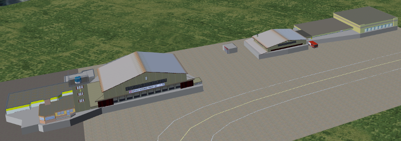
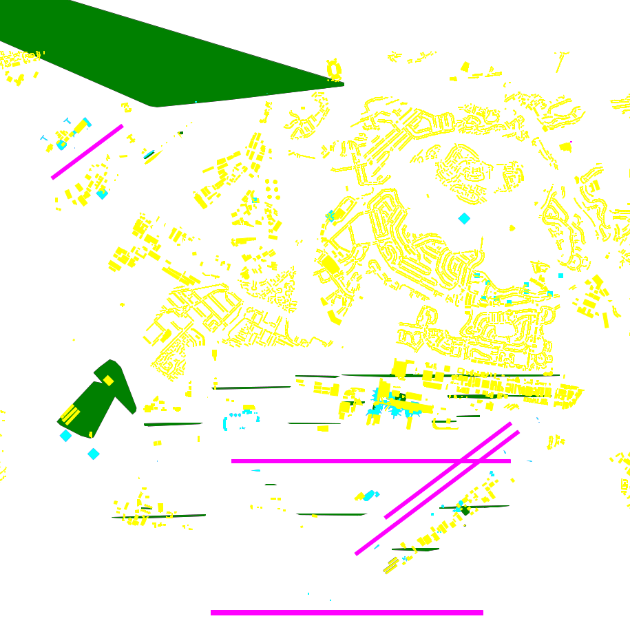
Examples of overlap objects based on static objects at LSZS (light grey structures at bottom of buildings):
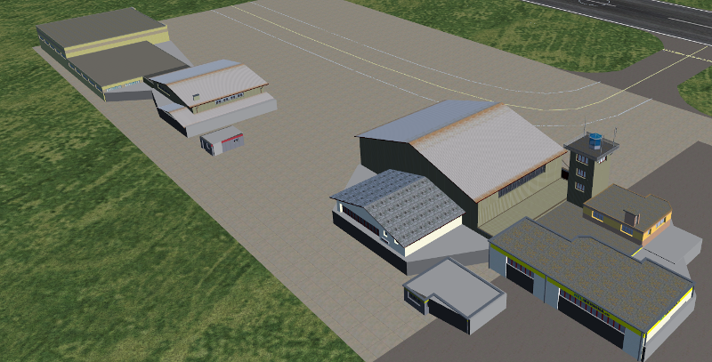
An example of difficult to handle situations is PHNL (Hawaii), where several objects inside the ac-file have rotations. The picture below shows the blocked areas (green) automatically detected. E.g. the large green area top left is a static object for the Admiral Bernard Chick Clarey Bridge. At the PHNL airport the green stripes parallel to the runway should actually be rather large areas covering most of the hangar areas of the airport.
The next image shows the blocked areas by parameter as well as the code to define these areas. There are at least two problems with this: (a) such issues cannot be detected automatically and (b) it is tedious and error prone to define these polygons. This is more a proof of concept and a “hack” for PHNL than anything else.
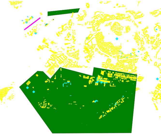
Remark in the parameters below that for roads only the bridge has been excluded - that is because it has been tested visually (again: tedious and slow).
_admiral_clarey_bridge = [(-157.953, 21.3693), (-157.953, 21.3671), (-157.9356, 21.3690), (-157.9346, 21.3711)]
_phnl_airport = [(-157.9015, 21.3354), (-157.9264, 21.3393), (-157.9272, 21.3347), (-157.9459, 21.3393),
                (-157.9516, 21.3331), (-157.9558, 21.3371), (-157.9589, 21.3373), (-157.9694, 21.3287),
                (-157.9503, 21.3038), (-157.9048, 21.3040)]
OVERLAP_CHECK_EXCLUDE_AREAS_ROADS = [_admiral_clarey_bridge]
OVERLAP_CHECK_EXCLUDE_AREAS_BUILDINGS = [_admiral_clarey_bridge, _phnl_airport]
Rectify Buildings
Rectifies angles of corners in buildings to 90 degrees as far as possible (configurable). This operation works on existing buildings as mapped in OSM. It corrects human errors during mapping, when angles are not straight 90 degrees (which they are in reality for the major part of corners). I.e. there is no new information added, only existing information corrected.
This operation is mainly used for eye-candy and to allow easier 3-D visualization. It can be left out if you feel that the OSM mappers have done a good job / used good tooling. On the other hand the processing time compared to other operations is negligible.
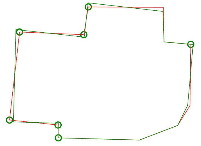
The following picture shows an example of a rectified building with a more complex layout. The results are more difficult to predict the more corners there are. The red line is the original boundary, the green line the rectified boundary. Green circles are at corners, where the corner’s angle is different from 90 degrees but within a configurable deviation (typically between 5 and 10 degrees). Corners shared with other buildings are not changed by the rectify algorithm (not shown here).
Please note that if you are annoyed with angles in OSM, then you have to rectify them manually in OSM. One way to do that is to use JOSM and related plugins.
| Parameter | Type | Default | Description / Example |
|---|---|---|---|
| RECTIFY_ENABLED | Boolean | True | Toggle whether the rectify operation should be used. |
| RECTIFY_90_TOLERANCE | Number | 0.1 | Small tolerance from 90 degrees not leading to rectification of corner. |
| RECTIFY_MAX_90_DEVIATION | Number | 7 | By how much an angle can be smaller or larger than 90 to still be rectified. You might need to experiment a bit and use plotting to determine a good value. |
| RECTIFY_MAX_DRAW_SAMPLE | Number | 20 | How many randomly chosen buildings having rectified corners shall be plotted. The more buildings the better for comparison. However plotting can take quite some time and system resources. |
| RECTIFY_SEED_SAMPLE | Boolean | True | If set to True then the randomizer uses a different seed each time. In some situations it might be better when the same set of random buildings are plotted each time - e.g. when experimenting with parameters and wanting to compare the outcomes. |
Light Effects on Buildings
Parameters for some light effects.
| Parameter | Type | Default | Description / Example |
|---|---|---|---|
| OBSTRUCTION_LIGHT_MIN_HEIGHT | Integer | 150 | Puts red obstruction lights on buildings >= the specified number levels. If you do not want this, then just set the value to 0. The official FAA source specifies 499 feet (153 m) as a rule. |
| BUILDING_FAKE_AMBIENT_OCCLUSION | Boolean | True | Fake ambient occlusion by darkening facade textures towards the ground, using the formula 1 - VALUE * exp(- AGL / HEIGHT ) during texture atlas generation. |
| BUILDING_FAKE_AMBIENT_OCCLUSION_HEIGHT | Number | (see above) | |
| BUILDING_FAKE_AMBIENT_OCCLUSION_VALUE | Number | 0.6 | (see above) |
Generating Buildings Where OSM is Missing Buildings
It is possible to let osm2city generate buildings, where it is plausible that there in reality would be buildings, but buildings were not mapped in OSM. The following set of parameters make some customisation to specific areas possible. However parts of the processing is rather hard-coded (e.g. the available buildings are defined in code in module owbb/would_be_buildings.py in function _read_building_models_library(). Still the results are much better than an empty scene.
No additional buildings are generated inside zones for aerodromes.
A lot of processing is dependent on land-use information (see e.g. Land-use Handling and Land-use Parameters). For a short explanation of the process used see Generate Would-Be Buildings.
In settlement areas an attempt is made to have the same terrace houses or apartment buildings along both sides of a way.
The first set of parameters determines the overall placement heuristics:
| Parameter | Type | Default | Description / Example |
|---|---|---|---|
| OWBB_GENERATE_BUILDINGS | Boolean | False | Set this to True to generate buildings. |
| OWBB_USE_GENERATED_LANDUSE_FOR_B.._GENERATION | Boolean | False | Generated land use is based on existing OSM buildings but missing land-use information. Therefore there is a fair chance that no additional buildings are plausible. |
| OWBB_USE_EXTERNAL_LANDUSE_FOR_B.._GENERATION | Boolean | True | External land-use is only added, where OSM is missing and no generated
land-use is available. Currently this only land-use from FlightGear (parameter
OWBB_USE_BTG_LANDUSE), which is why most probably plausible buildings
should be generated. |
| OWBB_STEP_DISTANCE | Integer | 2 | How many meters along the way to travel before trying to set a building again. Smaller values might be more accurate, but also increase processing time. |
| OWBB_MIN_STREET_LENGTH | Integer | 10 | How long a way needs to be at least to be considered for generating buildings along. |
| OWBB_MIN_CITY_BLOCK_AREA | Integer | 200 | The minimal area of a city block along a way to be considered for generating buildings. |
| OWBB_RESIDENTIAL_HIGHWAY_MIN_GEN_SHARE | Decimal | 0.3 | If there are already buildings along the way: what is the minimal share of an uninterrupted length along the way to consider for terraces or apartments (detached houses might still be “built”). |
| OWBB_ZONE_AREA_MAX_GEN | Decimal | 0.1 | If the share of floor area of exiting OSM buildings compared to the whole area is above this value, then no extra buildings are placed. In the future this value might need to be specific per settlement type. |
| OWBB_HIGHWAY_WIDTH_FACTOR | Decimal | 1.3 | Factor applied to highway width in order to push buildings exponential more away from high level highways (highway.width ** factor) |
The second set of parameters determines the type of residential buildings to use and the distances between the buildings and the street as well as what happens in the backyard. The width of a building is along the street, the depth of a building is away from the street (front door to back door).
| Parameter | Type | Default | Description / Example |
|---|---|---|---|
| OWBB_RESIDENTIAL_RURAL_TERRACE_SHARE | Decimal | 0.1 | The share of terraces / row houses in rural settlement areas. Most houses are detached, which is the default. |
| OWBB_RESIDENTIAL_PERIPHERY_TERRACE_SHARE | Decimal | 0.25 | Ditto in periphery settlement areas. |
| OWBB_RESIDENTIAL_RURAL_APARTMENT_SHARE | Decimal | 0.1 | The share of apartment buildings in rural settlement areas. |
| OWBB_RESIDENTIAL_PERIPHERY_APARTMENT_SHARE | Decimal | 0.3 | Ditto in periphery settlement areas. |
| OWBB_RESIDENTIAL_DENSE_TYPE_SHARE | Dict | In dense areas not everything is attached like in block or centre settlement
areas. It can be quite region specific. Therefore there is quite a choice for
specifying the distribution. E.g.
{'detached': 0.1, 'terraces': 0.1, 'apartments': 0.3, 'attached': 0.5}. |
|
| OWBB_RESIDENTIAL_TERRACE_MIN_NUMBER | Integer | 4 | The minimum number of terrace houses to fit along a street before it is considered to build terraces along the way. |
| OWBB_RESIDENTIAL_TERRACE_TYPICAL_NUMBER | Integer | 5 | The typical number of terrace houses attached to each other before there will be a break. The actual number is randomized around this value. |
| OWBB_RESIDENTIAL_SIDE_FACTOR_PERIPHERY | Decimal | 1.0 | The default buffer on the side of detached houses and apartment houses is the sqaure root of the house’s width. So the distance between two houses gets the square root of the one house’s width plus the square root of the other house’s width. This factor is multiplied to allow some linear correction for region specific adaptation. E.g. in Switzerland the houses tend to be farther apart along the street than in Denmark (the opposite is true for the backyard). This factor is used for rural and periphery settlement types. |
| OWBB_RESIDENTIAL_SIDE_FACTOR_DENSE | Decimal | 0.8 | Ditto for dense settlement type. Attached houses and terrace houses have a distance of ca. 0 (it is not exactly 0 due to the way placements are made in the heuristics - but close enough; you can play with the step distance). |
| OWBB_RESIDENTIAL_BACK_FACTOR_PERIPHERY | Decimal | 2.0 | Same as the ..SIDE_FACTOR.., but now for the back. Again the starting point is a square root - this time of the building’s depth. |
| OWBB_RESIDENTIAL_FRONT_FACTOR_PERIPHERY | Decimal | 1.0 | Same as the ..SIDE_FACTOR.., but now for the back. The starting point is the square root of the building’s width. |
| OWBB_FRONT_DENSE | Decimal | 3.0 | The distance in metres between the street and the front. Same for settlement
types dense, block and centre. |
Finally a set of parameters for industrial buildings:
| Parameter | Type | Default | Description / Example |
|---|---|---|---|
| OWBB_INDUSTRIAL_LARGE_MIN_AREA | Integer | 500 | The minimal number of square metres for an industrial building being considered large. |
| OWBB_INDUSTRIAL_LARGE_SHARE | Decimal | 0.4 | If the building zone type is industrial, then this share is used between large buildings and smaller buildings. |
| OWBB_INDUSTRIAL_BUILDING_SIDE_MIN | Decimal | 2.0 | The minimal buffer around a building - so the total distance between two industrial buildings is at least twice this value. The actual value used is chosen randomly between the .._SIDE_MIN and .._SIDE_MAX. |
| OWBB_INDUSTRIAL_BUILDING_SIDE_MAX | Decimal | 5.0 | See above. |
Linear Objects (Roads, Railways)
Parameters for roads, railways and related bridges. One of the challenges to show specific textures based on OSM data is to fit the texture such that it drapes ok on top of the scenery. Therefore several parameters relate to enabling proper draping.
| Parameter | Type | Default | Description / Example |
|---|---|---|---|
| BRIDGE_MIN_LENGTH | Decimal | Discard short bridges and draw roads or railways instead. | |
| MIN_ABOVE_GROUND_LEVEL | Decimal | 0.1 | How much a highway / railway is at least hovering above ground |
| DISTANCE_BETWEEN_LAYERS | Decimal | 0.2 | How much different layers of roads/railways at the same node are separated. |
| MIN_EMBANKMENT_HEIGHT | Decimal | 0.4 | How much extra elevation compared to ground (v_add) there is, before an embankment is added at the side(s). This happens especially in bumpy areas and for roads along a steep hill side. |
| MAX_TRANSVERSE_GRADIENT | Decimal | 0.1 | If the difference between the elevation at the right edge of a road and the elevation at the left edge of the road divided by the width of the road is larger than the gradient, then the road surface is levelled by adding v_add. Otherwise it is accepted that the road is a bit sloped from left to right. |
| HIGHWAY_TYPE_MIN | Integer | 4 | The lower the number, the smaller ways in the highway hierarchy are added. Currently the numbers are as follows (see roads.py -> HighwayType). motorway = 12 trunk = 11 primary = 10 secondary = 9 tertiary = 8 unclassified = 7 road = 6 residential = 5 living_street = 4 service = 3 pedestrian = 2 slow = 1 (cycle ways, tracks, footpaths etc). |
| POINTS_ON_LINE_DISTANCE_MAX | Integer | 1000 | The maximum distance between two points on a line. If longer, then new points are added. This parameter might need to get set to a smaller value in order to have enough elevation probing along a road/highway. Together with parameter MIN_ABOVE_GROUND_LEVEL it makes sure that fewer residuals of ways are below the scenery ground. The more uneven a scenery ground is, the smaller this value should be chosen. The drawback of small values are that the number of faces gets bigger affecting frame rates. |
| MAX_SLOPE_ROAD | Decimal | 0.15 | The maximum allowed slope. It is used for ramps to bridges, but it is also used for other ramps. Especially in mountainous areas you might want to set higher values. This leads to steeper ramps to bridges, but give much fewer residuals with embankments. |
| MAX_SLOPE_MOTORWAY | Decimal | 0.07 | (ditto) for motorways. It is seldom that motorways have lopes more than 0.04, but e.g. in Switzerland there are places with over 6% - e.g. A12. |
| MAX_SLOPE_RAILWAY | Decimal | 0.08 | (ditto) for railways. With adhesion only railways are along motorways in terms of max slopes. |
| MAX_SLOPE_TRAM | Decimal | 0.14 | (ditto) for trams, which also use adhesion, but can be steeper. |
| MAX_SLOPE_RACK | Decimal | 0.49 | For railways with racks the steepest is Pilatus Railway with 48% incline. |
| USE_TRAM_LINE | Boolean | False | Often tram lines are on top of existing roads or between. This can lead to roads being (partially) hidden etc. |
With residuals:
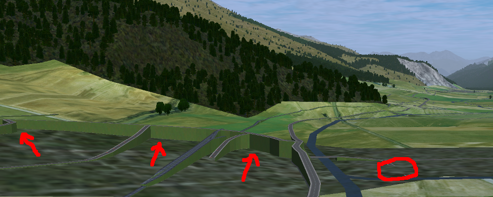
After adjusted MAX_SLOPE_* and POINTS_ON_LINE_DISTANCE_MAX parameters:
Land-Use
Land-use data is only used for built-up area in osm2city. All other land-use is per the scenery in FlightGear. The main use of the land-use information processed is to determine building types, building height etc. for those buildings (often the majority), where this information is lacking and therefore must be obtained by means of heuristics. See Land-use for an overall description.
| Parameter | Type | Default | Description / Example |
|---|---|---|---|
| OWBB_LANDUSE_CACHE | Boolean | False | Instead of calculating land-use related stuff including buildings from scratch each time, use cached (but possibly stale) data for speed-up. |
Complement OSM Land-Use Information
These operations complement land-use information from OSM based on some simple heuristics, where there currently are no land-use zones for built-up areas in OSM: If there are clusters of buildings outside of registered OSM land-use zones, then zones are added based on clusters of buildings and buffers around them. The land-use type is based on information of building types, amenities etc. — if available.
| Parameter | Type | Default | Description / Example |
|---|---|---|---|
| OWBB_USE_BTG_LANDUSE | Boolean | False | Read FlightGear scenery (BTG-files from existing TerraSync scenery) for land-use data to complement (not replace) data from OSM. |
| OWBB_GENERATE…_BUILDING_BUFFER_DISTANCE | Number | 30 | The minimum buffering distance around a building. |
| OWBB_GENERATE…_BUILDING_BUFFER_DISTANCE_MAX | Number | 50 | The maximum buffering distance around a building. The actual value is a function of the previous parameter and the building’s size (the larger the building the larger the buffering distance - up to this max value. |
| OWBB_GENERATE_LANDUSE_LANDUSE_HOLES_MIN_AREA | Number | 20000 | The minimum area for a hole within a generated land-use that is kept as a hole (square metres). |
| OWBB_GENERATE…_SIMPLIFICATION_TOLERANCE | Number | 20 | The tolerance in metres used for simplifying the geometry of the generated land-use boundaries. Tolerance means that all points in the simplified land-use will be within the tolerance distance of the original geometry. |
| OWBB_SPLIT_MADE_UP_LANDUSE_BY_MAJOR_LINES | Boolean | True | Splits generated land-use by major lines, as typically land-use changes occur across larger boundaries. “Major lines” here are motorways, most railways (not trams) and waterways classified in OSM as rivers and canals. |
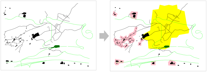
On the left side of the picture below the original OSM-data is shown, where there only is one land-use zone (green), but areas with buildings outside of land-use zones as well as several streets without buildings (which from an arial picture actually have lots of buildings — they have just not been mapped in OSM.
On the right side of the picture the pink areas are generated based on building clusters and the yellow zone is from CORINE data.
Generating Areas Where Roads are Lit
Land-use information is used to determine which roads are lit during the night (in addition to those roads which in OSM are explicitly tagged as being lit).
The resulting built-up areas are also used for finding city and town areas — another reason why the values should be chosen conservative, i.e. large.
| Parameter | Type | Default | Description / Example |
|---|---|---|---|
| OWBB_BUILT_UP_BUFFER | Number | 50 | The buffer distance around built-up land-use areas to be used for lighting of streets. The number is chosen pretty large such that as many building zone clusters as possible are connected. Also it is not unusual that the lighting of streets starts a bit outside of a built-up area. |
| OWBB_BUILT_UP_AREA_HOLES_MIN_AREA | Number | 100000 | The minimum area in square metres a hole in a LIT_BUFFER needs to have to be not lit. In general this can be quite a large value and larger than e.g. parameter OWBB_GENERATE_LANDUSE_LANDUSE_HOLES_MIN_AREA. |
| OWBB_BUILT_UP_MIN_LIT_AREA | Number | 100000 | The minimum area of a lit area, such that it is actually used for lighting of
streets. Given buffering with OWBB_BUILT_UP_BUFFER alone is already a
large area, this value must not be chosen too small. |
Size of Concentric Settlement Type Rings
The formula for the radius of the outer border of the ring is:
radius = population^OWBB_PLACE_RADIUS_EXPONENT * OWBB_PLACE_RADIUS_FACTOR
| Parameter | Type | Default | Description / Example |
|---|---|---|---|
| OWBB_PLACE_POPULATION_DEFAULT_CITY | Integer | 200000 | The default population for a settlement tagged with place=city, where the
population size is not tagged. |
| OWBB_PLACE_POPULATION_DEFAULT_TOWN | Integer | 20000 | Ditto for place=town. |
| OWBB_PLACE_POPULATION_MIN_BLOCK | Integer | 15000 | The minimum amount of people living in a place=town for it to have a
settlement type block (i.e. where all builings are attached).
If the population is based on default, then no block will be assigned. |
| OWBB_PLACE_RADIUS_EXPONENT_CENTRE | Number | 0.5 | The exponent for calculating the radius for settlement type centre, i.e.
1/2. |
| OWBB_PLACE_RADIUS_EXPONENT_BLOCK | Number | 0.6 | Ditto for type block, i.e. 5/8. |
| OWBB_PLACE_RADIUS_EXPONENT_DENSE | Number | 0.666 | Ditto for type dense, i.e. 2/3. |
| OWBB_PLACE_RADIUS_FACTOR_CITY | Number | Linear correction factor for radius when dealing with place=city. |
|
| OWBB_PLACE_RADIUS_FACTOR_TOWN | Number | Ditto for place=town. |
|
| OWBB_PLACE_TILE_BORDER_EXTENSION | Integer | 10000 | Extension of the perimeter (tile borders) to read place information from, as e.g. a city might extend across til border areas. |
| OWBB_PLACE_CHECK_DENSITY | Boolean | False | Should only be used if majority of all buildings are mapped in OSM. Otherwise settlement type will be downgraded e.g. in areas based on BTG etc. Mostly for testing purposes and prrof of concept. |
| OWBB_PLACE_SANITY_DENSITY | Number | 0.15 | Make sure that settlement type dense is assigned, if the density of a building zone is larger than a given ratio and the settlement type is rural or periphery. The density is calculated as the total of all buildings’ floor area (inner rings’ areas do also count) divided by the area of the building zone. Likewise if the density is lower than the ratio, but the settlement type is dense or block (not centre), then the type is changed to periphery. |
Textures
| Parameter | Type | Default | Description / Example |
|---|---|---|---|
| ATLAS_SUFFIX | String | (empty) | Add the the suffix to the texture atlas (also light-map) in osm2city-data
including an underscore (e.g. ‘foo’ leads to atlas_facades_foo.png). |
| TEXTURES_ROOFS_NAME_EXCLUDE | List | [] | List of roof file names to exclude, e.g. [“roof_red3.png”, “roof_orange.png”].
The file names must be relative paths to the tex.src directory within
PATH_TO_OSM2CITY_DATA.
Be aware the excluding roofs can lead to indirectly excluding facade textures,
which might be depending on provided roof types.
An empty list means that no filtering is done. |
| TEXTURES_FACADES_NAME_EXCLUDE | List | [] | Same as TEXTURES_ROOFS_EXCLUDE but for facades — e.g.
[“de/commercial/facade_modern_21x42m.jpg”]. |
| TEXTURES_ROOFS_PROVIDE_EXCLUDE | List | [] | List of provided features for roofs to exclude, e.g. [“colour:red”]. |
| TEXTURES_FACADES_PROVIDE_EXCLUDE | List | [] | Ditto for facades. |
| TEXTURES_REGIONS_EXPLICIT | List | [] | Explicit list of regions to include. If list is empty, then all regions are accepted. There is also a special region “generic”, which corresponds to top directory structure. In many situations it might not make sense to include “generic”, as it provides a lot of colours etc. (which however could be filtered with the other parameters). |
| TEXTURES_EMPTY_LM_RGB_VALUE | Integer | 35 | If a texture does not have an explicit light-map (i.e. same file name plus “_LM”, then a default light-map is constructed with RGB(VALUE, VALUE, VALUE). |
Other Parameters
Detailed Features
The following parameters determine, whether specific features for procedures pylons respectively details will be generated at all.
| Parameter | Type | Default | Description / Example |
|---|---|---|---|
| C2P_PROCESS_POWERLINES | Boolean | True | pylons: Generate electrical power lines (incl. cables) |
| C2P_PROCESS_WIND_TURBINES | Boolean | True | pylons: wind turbines |
| C2P_PROCESS_STORAGE_TANKS | Boolean | True | pylons: Storage tanks either mapped as nodes or ways in OSM |
| C2P_PROCESS_CHIMNEYS | Boolean | True | pylons: Chimneys either mapped as nodes or ways in OSM |
| C2P_PROCESS_TREES | Boolean | False | pylons: Trees as per OSM tagging or interpreted in parks, cemeteries etc.
This works only in FlightGear Next. |
| C2P_PROCESS_POWERLINES_MINOR | Boolean | False | details: Only considered if C2P_PROCESS_POWERLINES is True |
| C2P_PROCESS_AERIALWAYS | Boolean | False | details: Aerial ways is currently experimental and depends on local shared
objects. |
| C2P_PROCESS_OVERHEAD_LINES | Boolean | False | details: Railway overhead lines (pylons and cables) |
| C2P_PROCESS_STREETLAMPS | Boolean | False | details: Always disabled. It would drain your resources in larger
sceneries. |
| DETAILS_PROCESS_PIERS | Boolean | True | details: Generate piers and boats |
| DETAILS_PROCESS_PLATFORMS | Boolean | True | details: Generate railway platforms |
Database
OSM data is read from a PostGIS database. See also OSM Data in Database.
| Parameter | Type | Default | Description / Example |
|---|---|---|---|
| DB_HOST | String | n/a | The host name of the computer running PostGIS (e.g. localhost). |
| DB_PORT | Integer | 5432 | The port used to connect to the host (5433 for Postgres 9,x+) |
| DB_NAME | String | n/a | The name of the database (e.g osmogis). |
| DB_USER | String | n/a | The name of the user to be used to read from the database. Can be read-only. |
| DB_USER_PASSWORD | String | n/a | The password for the DB_USER. |
Skipping Specific Buildings and Roads/Railways
There might be situations, when you need to skip certain buildings or roads/railways, because e.g. the overlap checking does not work or the OSM features simply do not fit with the FlightGear scenery. Often it should be checked, whether the OSM data really is correct (if not, then please directly update the source in OSM) or the FlightGear scenery data is not correct (if not, then please check, whether source data can be improved, such that future versions of the scenery are more in line with reality and thereby with OSM data).
In order to temporarily exclude certain buildings or roads/railways, you can use parameter SKIP_LIST. For buildings you can either specify the OSM id or (if available) the value of the name tag. For roads/railways only the OSM id can be used.
E.g. SKIP_LIST = ['St. Leodegar im Hof (Hofkirche)', 87220999]
On the other hand side there might be situations, where certain STG-entries should not be checked for overlap checking. For that situation parameter SKIP_LIST_OVERLAP can be used as a list of *.ac or *.xml file names which should not be used for overlap tests
Clipping Region
The boundary of a scenery as specified by the parameters boundary command line argument is not necessarily sharp. As described in Getting OpenStreetMap Data it is recommended to use completeWays=yes, when manipulating/getting OSM data - this happens also to be the case when using the OSM Extended API to retrieve data. However there are no parameters to influence the processing of OSM nodes and OSM ways depending on whether they are inside / outside the boundary or intersecting.
The processing is as follows:
- buildings.py: if the first node is inside the boundary, then the whole building is processed — otherwise not
- roads.py: if not entirely inside then split at boundary, such that the first node is always inside and the last is either inside by default or the first node outside for splitting.
- piers.py: as above for piers
- platforms.py: as above for platforms
- pylons.py
- storage tanks: if the centroid is inside the boundary, then the whole storage tank is processed — otherwise not
- wind turbines and chimneys: no checking because the source data for OSM should already be extracted correctly
- aerial ways: if the first node is inside the boundary, then the whole aerial way is processed — otherwise not (assuming that aerial ways are short)
- power lines and railway overhead lines: as for roads. If the last node was split, then no shared model is placed assuming it is continued in another tile (i.e. optimized for batch processing across tiles)